 | ||
|
|
[Background][About the Study Area][Analysis Process][ Suitability Assessment][Home] | |
In
preparing to undertake an environmental analysis of the San Eduardo Ranch
property, the team first investigated current issues and background information
by contacting interested persons and relevant organizations.
The natural history of the area was reviewed through books and other
sources. The result of this investigation is summarized below, with contact or
availability information for further analysis. [Contact Persons] [Book Reviews] [Websites] [Relevant Organizations] [Home] Gabriel
del Bosque - City of Laredo William
Do little,
Professor, Department of Geography Willie
Dougherty - Laredo office Raphael
Garcia - City of Laredo Bridges Department Roy
Garcia - TXDOT Construction Office Jose Luis Llabona
-
Fideicomiso
para el Desarrollo Norte del Estado de Nuevo Leon Engineer
Negrete - International Boundary and Water Commission (IBWC) Dr.
Charles Palmer Miguel
Pavón Mike
Pescad - City of Laredo Bridges Department Carlos
Rodriguez - TX DOT Construction Office Thomas Tremblay -
Bureau of Economic Geology Department of Landscape Architecture Major field of interest is landscape architecture; he works on the topic of transboundary planning between Texas and Mexico in the corridor from San Antonio to Monterrey.
|
|
Berlandier, J. L.
(1980) Journey
to Mexico During the
Years 1826 to 1834. Vol. III, pp. 262-270.
Austin: Texas State Historical Association. [Center for American History] Eaton, David J.
(1996) Regional Assessment of Water Quality in the Rio Grande Basin. Eaton, David J.(1992)
Challenges in the Binational Management of Water Resources in the Rio Grande /
Rio Bravo. Eaton, David J.(1995)
NAFTA handbook for water resource managers and engineers. Eaton, David J.
(1987) The state of the Rio Grande/Rio Bravo : A Study of Water Resource
Issues Along
the Texas/Mexico Border. Tucson. [TD 225 R53 E28 1987
/ PCL Stacks, also in Undergr. Lib, BLAC, Geology Lib., Public Affairs Lib.] Eaton, David J.
(1983) A
Source book for Rio Grande/Rio Bravo Water Management : A Report. Emory,
William H. (1857) Report on the United States and Mexican Boundary Survey
Made Under the Direction of the Secretary of the Interior (Vol. 1 and 2)
Washington, DC: Cornelius Wendell, printer. Geiser, S. W.
(1948) Naturalists
of the Frontier. Dallas: Southern Methodist University. [Geology Library] Gelbach,
Frederick R. (1981) Mountain Islands and Desert Seas: A Natural History of
the U.S.-Mexican Borderlands. College Station, TX: Texas A&M University
Press. House, John
William. (1982) Frontier on the Rio Grande : A Political Geography of
Development and Social Deprivation. Pierson, H. L. (1998)
Housing, Economic Development, and Physical Planning: Towards
Convergence in the Two Laredos? Thesis, Master of Science in Community and
Regional Planning, University of Texas at Austin. Texas
Natural Resource Conservation Commission (1996). Regional Assessment of the Water Quality in the Rio Grande Basin.
Austin: TNRCC. U.S. Department of Agriculture, Natural Resource Conservation Service (formerly Soil Conservation Service), 19XX. Soil Survey of Webb County, Texas.
|
The following organizations were contacted regarding their interests and
projects in the study area. Information is compiled below in
report format. Contact information and links are provided, where
appropriate.
Fideicomiso
para el Desarrollo Norte del Estado de Nuevo Leon (FIDENOR) FIDENOR
is a state government trust located in Monterrey, Mexico, which has as its
mission the development of the northern region of the state of Nuevo Leon. Their
vision is to develop this area with the following principles in mind:
The agency is
currently focused on the development of the city of Colombia, which is the
closest settlement to the Colombia-Solidaridad Bridge. FIDENOR aims to develop
Colombia as a city that specializes in Foreign Trade, with the idea that in
time, it will become an important business center that can serve as an important
industrial, commercial and financial spearhead for Mexico as it continues its
integration process with North America. The current
goals of FIDENOR are:
The following
are some of the projects envisioned by FIDENOR for the city of Colombia: TRANSPORTATION
URBANIZATION
AGROCOM
(Center to Store, Process and Market Agricultural and Livestock Products)
DIATEC
(Industrial Park for the Development of High-Tech Industry) – A “Silicon
Valley”
COLOMBIA
CRAFTMANSHIP
COLOMBIA AIR
CARGO
COLOMBIA
RAILROAD PORT
DURCOL
NATAP
On January
26, 2000, I spoke with Jose Luis Llabona, who indicated that there was no
current moratorium on the development of Colombia: once an area is sold, the
owners can begin developing. He
also pointed out that the construction of the highway from Nuevo Laredo to
Colombia has been currently postponed, but that FIDENOR is doing its best to
impulse the project again. The fiscal
compound is apparently one of their most important projects. The establishment will encompass 332 ha and will have all the
services necessary for its smooth operation.
Mr. Llabona claimed that this facility will enable companies to move
their products from one country to the other in a shorter time frame than is
currently possible through other establishments. Mr. Llabona
said that companies that want to establish themselves in Colombia have to
present a plan to FIDENOR which has to include certain requisites, such as a
minimum of green areas. FIDENOR
studies the proposed plan, carries out a technical study of it, and depending on
their findings, they either approve it or not. He stated that studies of
environmental impact had been carried out in the area of Colombia in conjunction
with the Tec of Monterrey. On the
subject of polluting industries, FIDENOR does not foresee that such type of
industries will be settling in the area, and therefore does not think that this
type of pollution will be of great relevance to Colombia. From an email
sent to me by Mr. Llabona, it is clear that FIDENOR is willing to provide
detailed information about its projects, as long as one specifies exactly what
one wants to know. It would be very interesting to contact the people at the
Instituto Tecnológico de Monterrey who are collaborating with FIDENOR in the area of
Environmental Studies. International
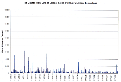
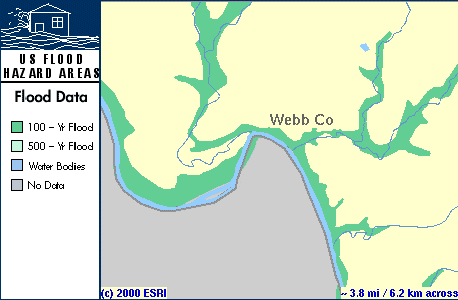
Boundary and Water Commission (IBWC) Historic flows for the Rio Grande at Nuevo Laredo are given in a table on the IBWC website. The data was collected daily beginning on May 1, 1900. The information is presented on approximately 570 pages and new data is added as it becomes available. In order to condense this data into a more legible format, I copied the data into an Excel spreadsheet and plotted it as a graph of flow (cubic meters per second) over time. Floodplain data was not available from the IBWC, so I searched
for a map at the FEMA website (www.fema.gov).
I found a map for the U.S. side of the Rio Grande at the project
location. (see screen capture
below) I think it would be very
useful to acquire a hard copy of the FEMA floodplain map at this location so we
can determine the approximate floodplain of the project site.
The class is creating a topography map for the project site using GPS
data, so the approximate floodplain could be drawn by using the floodplain
elevations shown on the US side on the FEMA map.
The Texas Clean Rivers Program of the IBWC produced a
Basin Highlights Report for 1999, which can be read at http://www.ibwc.state.gov/CRP/bhlrepo2.htm.
Rio Grande Segment 2304 (Rio Grande below Amistad Reservoir) is listed on
the EPA website on the impaired waters list.
The parameter of concern is listed as “pathogens”. Bureau
of Economic Geology The
Bureau of Economic Geology has one of the largest collections of core samples on
the United States. The core samples
are kept at the J.J. Pickle Research Campus in Austin, Texas, and at the Midland
Branch of the Core Research Center (5310A East Business I-20 in Midland, Texas).
A core data listing is included on the web site, and there are 49
listings of core samples in Webb County, Texas, which is the county across from
the San Eduardo project site on the other side of the Rio Grande.
To view the listing, please visit the core listing site at: www.utexas.edu/research/beg/ftp/cores_by_county/W The
samples are taken at varying depths, so there are samples (cores or cuttings)
available for the following formations: Edwards
limestone, Wilcox, Mirando, and Olmos. Tom Tremblay may have some data available in future semesters of this project. He was hoping to receive some geologic data from a colleague but he found out that the information will not be available this semester. He suggested that we call Tom Woodfin at Texas A&M, because he has worked form many years on the San Antonio-Monterrey corridor. Texas Department of
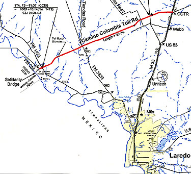
Transportation and City of Laredo, Texas While
the study area contains only one international bridge, another a short distance
South is soon to open. This will
make a total of four regionally. The
area is expected to grow tremendously in the next decade and these bridges will
quickly meet their capacity. There
are two bridges in Laredo, which currently handle the bulk of international
commercial traffic. However with
the opening of the World Trade Bridge, all commercial traffic will be routed
away from the Laredo bridges to the two Northern bridges (World Trade and
Solidaridad). The City of Laredo
has plans to refurbish bridge "number one" and make it into a
pedestrian bridge only to enhance the tourism aspect of the city, and leave
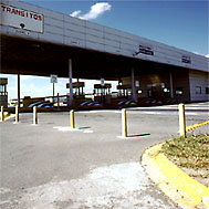
bridge "number two" for wheeled traffic - cars, bikes etc. Colombia
or Solidaridad Bridge located in Colombia in the state of Nuevo León.
Fidenor in Mexico has a large transhipment center under construction and
according to the City of Laredo is being held up not by money, but politics.
They need permits to finish completing the station, and that is where the
hold up is. From the U.S. side
going to Mexico, the Solidaridad bridge carried 25,952 trucks across in the month
of February 2000. That is up over
1,500 from the month before, and up ~4,500 from the same month last year.
It is estimated that about 3% more trucks cross coming into the U.S than
going the other way. So that would mean approximately 27,000 enter the U.S. during
February for a total of 53,000 both ways. They
do not know what the capacity of the bridge is at this point.
They won't know until they get "stagnant" performance measures
back from their data collection, and that is unlikely until after the World
Trade Bridge is open for a couple of years.
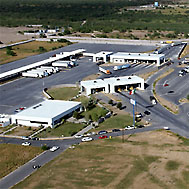
The
road that connects the Solidarid World
Trade Bridge Is
located in the state of Tamaulipas south of the Colombia (Solidaridad) bridge by
about 19 miles and opened on the U.S. side in April 2000.
The Mexican side is experiencing some delays however, and so most likely
it won't be fully operational until the middle of May.
This bridge is expected to increase the total number of trucks that
currently cross the border in both directions by 5%. The estimates after both bridges are fully operational is
107,000 trucks / month. The World
Trade bridge will link up with Loop 20 to form the western half of the Bob
Bullock Loop and connect with I-35. Loop
20 is slated for opening April 15th and the link to I-35 by mid June, 2000. Continue
to |
 trade
trade