 | ||
|
|
[Background][About the Study Area][Analysis Process][ Suitability Assessment][Home] | |
|
|
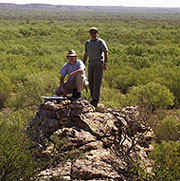
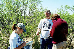
The information assembled here has been collected by students through fieldwork in the study area, research of available resources, and computational analysis. Professor Kent Butler is supervising this project. The following paragraphs illustrate the history of the study area and the mission of the project. Rancho San Eduardo was acquired by the Longoria brothers in the late 1940s from the son of Mexico's president. Since that time, it has been continuously operated as a farming and ranching operation, running 6,000 head of cattle at the peak of its agricultural production. Eduardo Longoria, Sr., a Renaissance man and senior member in a host of successful family enterprises throughout the Rio Grande valley, took responsibility for developing the ranch to maximize its profitability. He installed extensive water infrastructure to meet the demands of crop irrigation and livestock watering. The family engineered and constructed much of the water system. Irrigated fields have been used to cultivate cotton and other crops as part of the Longoria family's cotton-producing enterprises. Although the ranch originally totaled 50,000 hectares (125,000 acres), it has since been divided among family members. Eduardo Sr. retained approximately 2,000 hectares that make up what is known today as Rancho San Eduardo. This property represents the finest land from the original ranch because it includes the extensive water infrastructure, has significant river frontage and full access to the Carretera Riverena (riverine highway) along its southern border. In the 1970s, Eduardo Longoria, Jr., an Austin businessman, became actively involved in the management of Rancho San Eduardo, with responsibility for livestock sale/purchase and ranch operations. Additional irrigation infrastructure was installed in the mid-1980s and the ranch continued to prosper, running approximately 200 head of cattle. Some of the ranch workers have been living on the ranch for more than 20 years. Despite
this long history, recent changes in the surrounding areas have made it clear
that this land may not remain ranchland forever In the late 1990s, Eduardo Longoria Jr. applied his extensive experience in real estate and land development to begin studying sustainable development, permaculture and new town planning. His commitment to these ideals led him to develop ideas and conceptual proposals for building an ecologically-based and communally-managed community on the ranch property. In 1999, through a new friendship with Kent Butler, Professor of Community and Regional Planning at the University of Texas at Austin, Eduardo Jr. seriously discussed the possibility of doing conceptual planning for a community on the family ranch. In January 2000, the Longoria family made a gift to the UT School of Architecture to support the costs of offering an environmental analysis studio for master's students that would undertake the first phase of planning for a new town on Rancho San Eduardo.
|
 The
Visión: Frontera project is being
conducted as a series of studio courses in the Graduate Program in Community and Regional
Planning at the University of Texas at Austin, School of Architecture. It is
currently in the environmental analysis phase, with eight graduate students from
four disciplines participating.
The
Visión: Frontera project is being
conducted as a series of studio courses in the Graduate Program in Community and Regional
Planning at the University of Texas at Austin, School of Architecture. It is
currently in the environmental analysis phase, with eight graduate students from
four disciplines participating. 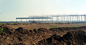 . In the mid-1990s, a new
international bridge was built just a few miles to the east. The Colombia-Solidaridad
bridge, which relieves some of the freight traffic from Laredo's bridges,
carries more than 25,000 trucks in each direction per month. The Mexican
state of Nuevo Leon has planned for extensive industrial expansion on lands
around the bridge, and is also completing an upgrade for the Carretera Riverena.
These changes indicate that development is moving into this region, and Rancho
San Eduardo is too close to current activity to ignore it.
. In the mid-1990s, a new
international bridge was built just a few miles to the east. The Colombia-Solidaridad
bridge, which relieves some of the freight traffic from Laredo's bridges,
carries more than 25,000 trucks in each direction per month. The Mexican
state of Nuevo Leon has planned for extensive industrial expansion on lands
around the bridge, and is also completing an upgrade for the Carretera Riverena.
These changes indicate that development is moving into this region, and Rancho
San Eduardo is too close to current activity to ignore it. |
The first phase of the study is a landscape assessment - an inventory and analysis of natural resources and their intrinsic opportunities and constraints for development. The class goal is to use classical and advanced techniques of landscape inventory and analysis to assess the development suitability of this unique property. Future phases will include:
Rancho San Eduardo has been intensively used, but it is still "fresh" land, in a sense, because it has never been developed for urban settlement. This represents a unique learning opportunity for students of community and regional planning. Modern urban landscapes typically are analyzed using a diversity of data types, but the challenges of managing such extensive data for a previously undeveloped site are significant and instructive.
Continue to |
 Rigorous
landscape assessment is often overlooked in the land development process,
frequently resulting in over-engineering that does not respond to natural
realities. This project assumes that sustainable development criteria for
a new community must begin with an understanding of the land and water.
Rigorous
landscape assessment is often overlooked in the land development process,
frequently resulting in over-engineering that does not respond to natural
realities. This project assumes that sustainable development criteria for
a new community must begin with an understanding of the land and water.